Utah offers landscapes that seem borrowed from another planet. From the otherworldly salt flats of Bonneville to the sculpted canyons of Antelope Canyon and the ancient petroglyphs at Newspaper Rock, each destination tells a different story. The Wave, Delicate Arch, and Fifth Water Hot Springs represent just a fraction of what awaits.
Keep reading as we explore the best places to go in Utah that will transform your understanding of what natural beauty can achieve.
1. The Wave: Lottery Winner’s Paradise
The Wave exists as nature’s masterpiece carved from 190-million-year-old Jurassic sandstone. Only 20 people per day receive permits through an online lottery system that runs months in advance.

I remember checking my email at 3 AM, discovering I’d won the lottery for March slots. The anticipation felt like waiting for concert tickets to your favorite band.
The 6-mile roundtrip hike requires navigation skills since no marked trail exists. Rangers provide a map and photo guide, but GPS coordinates become your lifeline in this maze of rock formations.
Quick Facts:
- Peak Season: March-May, September-November
- How to Get There: 44-mile drive south from Kanab on US-89
- Entrance Fee: From $9 per person (permit required)
- Suggested Stay: Day hike (6-8 hours)
- Notable Features: North and South Coyote Buttes, Melody Arch
2. Antelope Canyon: Cathedral of Light
Antelope Canyon carved itself through millions of years of flash flood erosion, creating slot canyon walls that rise 120 feet above the sandy floor. Light beams penetrate the narrow opening above, painting the walls in shades of orange and red.
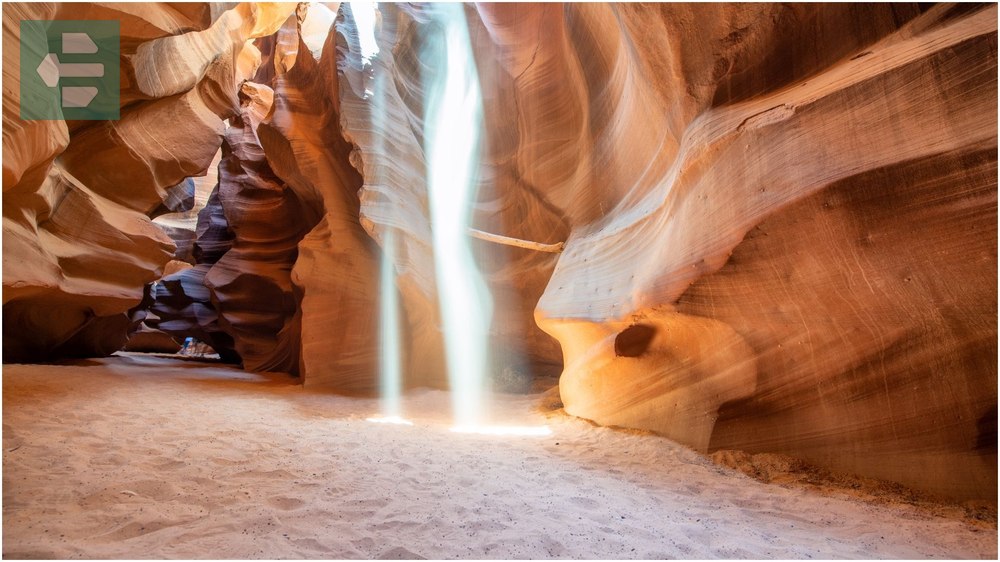
Upper Antelope Canyon allows easier access but draws larger crowds. Lower Antelope requires climbing metal ladders through narrow passages—a more adventurous route that rewards visitors with equally stunning formations.
Photography here demands patience. The famous light beams only appear during midday hours between late March and early October.
Quick Facts:
- Peak Season: March-October
- How to Get There: 7 miles southeast of Page, Arizona via Highway 98
- Entrance Fee: From $40 per person (guided tours mandatory)
- Suggested Stay: 2-3 hours
- Notable Features: Upper Antelope Canyon, Lower Antelope Canyon, Canyon X
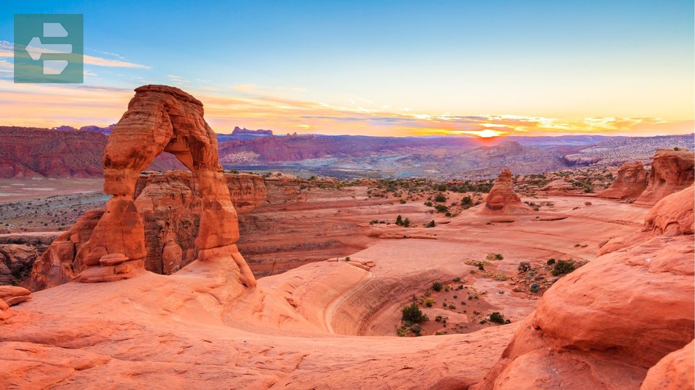
3. Delicate Arch: Utah’s Crown Jewel
Delicate Arch stands 65 feet tall, balanced on the edge of a sandstone bowl like a giant stone rainbow. This natural wonder appears on Utah’s license plates and served as the backdrop for countless proposals and family photos.

The 3-mile roundtrip hike crosses exposed slickrock with minimal shade. Start early morning or late afternoon to avoid midday heat and catch the arch glowing in golden light.
Local photographers know the secret: climb the ridge across from the arch for unobstructed shots without crowds of tourists posing beneath it.
Quick Facts:
- Peak Season: April-June, September-October
- How to Get There: Arches National Park, 11 miles north of Moab
- Entrance Fee: From $30 per vehicle (park entrance)
- Suggested Stay: Half day
- Notable Features: Fiery Furnace, Windows Section, Courthouse Towers
4. Bonneville Salt Flats: Earth’s White Mirror
Bonneville Salt Flats stretch across 30,000 acres of crystallized salt deposits left behind by ancient Lake Bonneville. The perfectly flat surface creates an otherworldly landscape where horizon lines disappear into infinity.
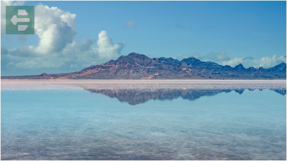
Speed records get set here regularly. The land speed record of 630 mph was achieved on these flats in 1970, and racing events still occur during Speed Week each August.
Visit during winter months when thin layers of water create mirror-like reflections of mountain ranges and sky. Bring extra water and sunglasses—the salt reflects sunlight with blinding intensity.
Quick Facts:
- Peak Season: November-March (for reflections)
- How to Get There: I-80 west from Salt Lake City, Exit 4
- Entrance Fee: Free
- Suggested Stay: 2-4 hours
- Notable Features: Floating Island, Silver Island Mountains, Danger Cave
5. Coyote Gulch: Hidden Canyon Paradise
Coyote Gulch winds through Glen Canyon National Recreation Area, featuring natural bridges, flowing water, and cottonwood groves that seem impossible in this desert landscape. Jacob Hamblin Arch spans the creek 125 feet above the canyon floor.
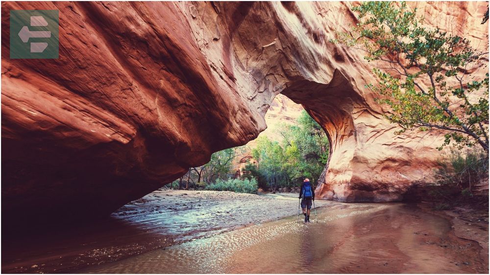
The 13-mile roundtrip backpacking route follows the Escalante River through narrow slot sections and wide amphitheaters. Quicksand exists in certain areas, so step confidently and keep moving if you feel your feet sinking.
I spent three days here in October, watching stars appear through the narrow canyon opening while coyotes called from the rim above. The sound echoed off canyon walls like nature’s own concert hall.
Quick Facts:
- Peak Season: April-June, September-November
- How to Get There: Hole-in-the-Rock Road from Escalante
- Entrance Fee: Free (backcountry permit recommended)
- Suggested Stay: 2-3 days backpacking
- Notable Features: Jacob Hamblin Arch, Coyote Natural Bridge, Stevens Arch
6. Valley of the Gods: Monument Valley’s Quiet Cousin
Valley of the Gods showcases red rock spires and mesas across 17 miles of unpaved scenic drive. These formations rival Monument Valley but receive a fraction of the visitors, creating an intimate experience with the landscape.
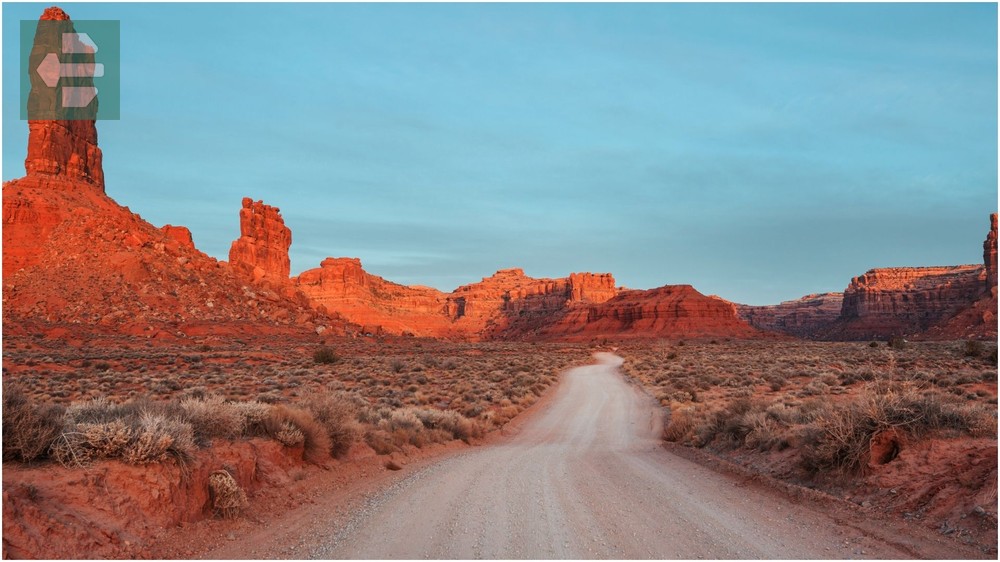
The dirt road requires high-clearance vehicles but remains passable for careful drivers in dry conditions. Seven major formations stand along the route, each named for their resemblance to familiar objects or people.
Mexican Hat Rock balances precariously on a narrow pedestal just outside the valley, marking the eastern entrance to this geological wonderland.
Quick Facts:
- Peak Season: April-June, September-November
- How to Get There: Highway 163 between Mexican Hat and Bluff
- Entrance Fee: Free
- Suggested Stay: Half day drive
- Notable Features: Mexican Hat Rock, Rooster Butte, Setting Hen Butte
7. Fisher Towers: Red Rock Skyscrapers
Fisher Towers rise from the desert floor like ancient skyscrapers, reaching heights of 900 feet through millions of years of erosion. The Titan stands as the tallest formation, challenging rock climbers from around the world.
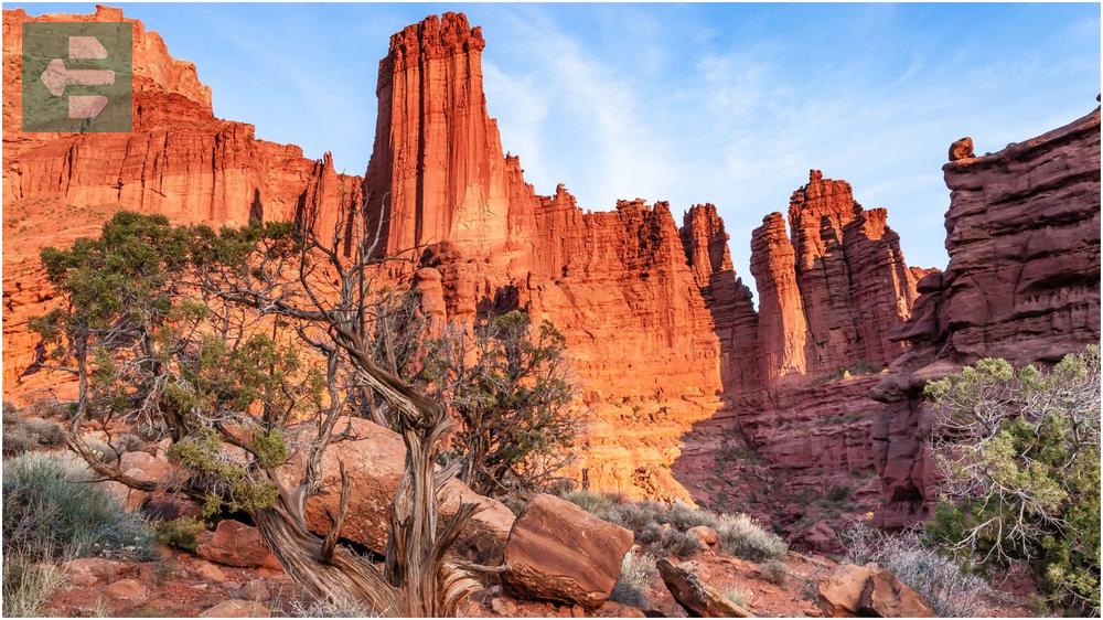
The 4.4-mile hiking trail leads to the base of these formations, offering close-up views of the precarious-looking red rock spires. Climbing routes here require advanced technical skills due to the fragile nature of the sandstone.
Early morning light transforms these towers into glowing pillars of fire, while evening light casts dramatic shadows across the surrounding landscape.
Quick Facts:
- Peak Season: March-May, September-November
- How to Get There: Highway 128 northeast of Moab, Fisher Towers Road
- Entrance Fee: Free
- Suggested Stay: Half day
- Notable Features: The Titan, Ancient Art, Cottontail Tower
8. Corona Arch: The Natural Bridge Giant
Corona Arch spans 140 feet across and rises 105 feet high, earning the nickname “Little Rainbow Bridge” for its massive proportions. The 3-mile roundtrip hike includes sections of slickrock scrambling and metal cables for assistance.

This natural bridge formed through different geological processes than typical arches, creating its distinctive shape through the erosion of underlying rock layers rather than direct weathering.
Standing beneath Corona Arch provides perspective on nature’s engineering capabilities. The opening frames distant La Sal Mountains perfectly, creating a natural picture window in the desert.
Quick Facts:
- Peak Season: March-May, September-November
- How to Get There: Potash Road (Highway 279) west of Moab
- Entrance Fee: Free
- Suggested Stay: Half day
- Notable Features: Bowtie Arch, Pinto Arch, Jeep Arch
9. Buccaneer Trail: Secret Scenic Drive
Buccaneer Trail connects Capitol Reef National Park to Goblin Valley through 36 miles of unmarked dirt roads crossing the San Rafael Desert. This route reveals hidden slot canyons, natural bridges, and geological formations missed by most visitors.

The trail requires high-clearance vehicles and good weather conditions. Flash flood dangers exist in wash crossings, so check forecasts before departing.
Local ranchers use portions of this route to move cattle, creating occasional traffic jams involving herds of cows rather than cars—a uniquely Utah experience.
Quick Facts:
- Peak Season: April-June, September-October
- How to Get There: From Capitol Reef visitor center via Scenic Drive
- Entrance Fee: Free (beyond park boundaries)
- Suggested Stay: Full day
- Notable Features: Temple of the Sun, Temple of the Moon, Wild Horse Canyon
10. Fifth Water Hot Springs: Mountain Oasis
Fifth Water Hot Springs cascade down natural terraces in Diamond Fork Canyon, creating pools of varying temperatures surrounded by alpine forest. The mineral-rich water maintains temperatures between 85-110 degrees Fahrenheit year-round.

The 2.3-mile hiking trail follows Diamond Fork River through changing ecosystems, from desert scrub to mountain forest. Multiple hot spring pools offer different soaking experiences, from shallow warm pools to deeper hot pools.
Winter visits provide the most dramatic experience, with steam rising from hot pools while snow covers surrounding pine trees—nature’s own spa treatment in a winter wonderland setting.
Quick Facts:
- Peak Season: Year-round (winter requires snowshoes)
- How to Get There: Spanish Fork Canyon via Highway 6
- Entrance Fee: Free
- Suggested Stay: Half day
- Notable Features: Diamond Fork River, Monk’s Hollow, Rays Valley
11. Reflection Canyon: Instagram’s Hidden Secret
Reflection Canyon curves through Glen Canyon National Recreation Area, creating a horseshoe bend that mirrors the Colorado River below. The viewpoint sits 1,500 feet above the water, offering dramatic perspectives of the river’s meandering path.

The unmarked 3-mile hike requires navigation skills across slickrock terrain with no established trail. GPS coordinates become essential since cairns and footprints provide the only guidance through this wilderness area.
Photography here demands patience and timing. Early morning light illuminates the canyon walls while calm water creates perfect reflections of the curved rock formations.
Quick Facts:
- Peak Season: March-May, September-November
- How to Get There: Hole-in-the-Rock Road from Escalante
- Entrance Fee: Free
- Suggested Stay: Half day
- Notable Features: Colorado River overlook, Navajo sandstone formations
12. Newspaper Rock: Ancient Art Gallery
Newspaper Rock displays over 650 petroglyphs carved into a single sandstone face over 2,000 years by various Native American cultures. The rock art tells stories through symbols depicting hunting scenes, human figures, and geometric patterns.

This outdoor museum requires no hiking—the petroglyphs sit directly beside the paved road, making it one of Utah’s most accessible ancient art sites. A viewing platform provides optimal angles for photography and interpretation.
Archaeologists continue studying these symbols, with some petroglyphs dating back to the Archaic period while others were created by more recent Navajo and Ute peoples.
Quick Facts:
- Peak Season: Year-round
- How to Get There: Highway 211 west of Monticello toward Canyonlands
- Entrance Fee: Free
- Suggested Stay: 1 hour
- Notable Features: Indian Creek corridor, Lockhart Basin, Canyonlands access
Utah’s best places offer more than scenic views—they provide connections to geological time scales that humble human perspective. Each location teaches patience, rewards preparation, and delivers experiences that photographs cannot fully capture.
Your Utah adventure begins with choosing which impossibility to witness first. The Wave’s flowing sandstone, Delicate Arch’s perfect balance, or Fifth Water’s steaming pools—each destination promises transformation.
Pack extra water, charge your camera, and prepare for landscapes that will reset your definition of beautiful. Utah waits with secrets carved in stone and stories written in light.