Texas offers rugged peaks, hidden springs, and desert canyons that rival any landscape in America. The best hiking places in Texas include Guadalupe Peak, Big Bend National Park, Enchanted Rock, and Palo Duro Canyon.
Discover trails where ancient limestone meets desert sky, where wildflowers bloom in forgotten valleys, and where every step reveals why Texas hiking deserves a spot on your bucket list.
1. Guadalupe Peak: The Rooftop of Texas
Guadalupe Peak stands 8,751 feet above sea level—the highest point in Texas. The trail climbs 3,000 feet over 4.2 miles, demanding respect from every hiker who attempts it.
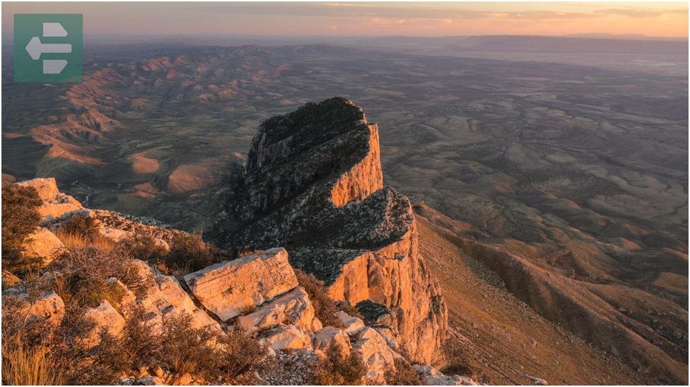
I reached the summit at dawn one October morning and watched the sun paint the Chihuahuan Desert gold. The silence was absolute. No cell towers. No traffic. Just wind and the vast emptiness of West Texas stretching to Mexico.
The final push requires scrambling over loose rock. Bring gloves and plenty of water.
Quick Facts
- Peak Season: October-April
- How to Get There: Highway 62/180, 110 miles east of El Paso
- Entrance Fee: From $5 per person
- Suggested Duration: Full day hike
- Key Trails: Guadalupe Peak Trail, Devil’s Hall Trail
2. Big Bend National Park: Desert Wilderness
Big Bend covers 800,000 acres along the Rio Grande, where the Chisos Mountains rise from desert floor like ancient fortresses. The Santa Elena Canyon trail follows the river between towering limestone walls.
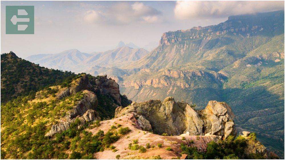
Lost Mine Trail offers the park’s best views without requiring overnight gear. The path winds through desert to mountain peaks, revealing layers of geological time.
Pack more water than you think you need. The desert here is unforgiving, beautiful, and bigger than some entire states.
Quick Facts
- Peak Season: November-March
- How to Get There: Highway 118 south from Alpine
- Entrance Fee: From $30 per vehicle
- Suggested Duration: 2-3 days minimum
- Key Trails: Lost Mine Trail, Santa Elena Canyon, South Rim Trail
3. Enchanted Rock State Natural Area: Pink Granite Giant
Enchanted Rock is a massive pink granite dome that rises 425 feet from the Hill Country. Native Americans considered it sacred, and hiking to the summit at sunrise explains why.

The main trail is deceptively challenging. Granite can be slippery, especially after rain. I learned this lesson the hard way one March morning, sliding down ten feet of smooth rock.
Local tip: arrive before 8 AM on weekends. The park closes when parking fills up.
Quick Facts
- Peak Season: March-May, October-November
- How to Get There: Highway 965, 18 miles north of Fredericksburg
- Entrance Fee: From $7 per person
- Suggested Duration: Half day
- Key Trails: Summit Trail, Loop Trail, Echo Canyon
4. Palo Duro Canyon State Park: Texas Grand Canyon
Palo Duro Canyon stretches 120 miles long and 800 feet deep, carved by the Prairie Dog Town Fork Red River. The canyon walls reveal 250 million years of geological history in brilliant red rock layers.

The Lighthouse Trail leads to the park’s iconic rock formation. It’s a 6-mile round trip across desert floor, where rattlesnakes and roadrunners share the landscape.
Visit during spring wildflower season when bluebonnets carpet the canyon floor in electric blue.
Quick Facts
- Peak Season: March-May, October-November
- How to Get There: Highway 217, 12 miles east of Canyon
- Entrance Fee: From $7 per person
- Suggested Duration: Full day
- Key Trails: Lighthouse Trail, Capitol Peak Trail, CCC Trail
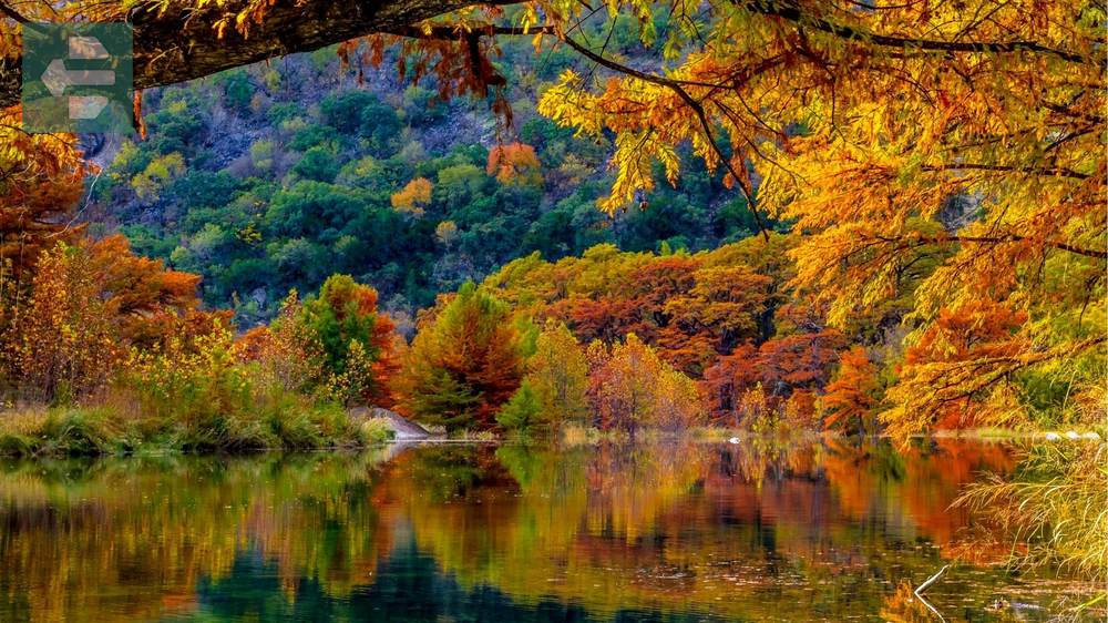
5. Lost Maples State Natural Area: Hill Country Autumn
Lost Maples transforms each November when bigtooth maples turn brilliant orange and red. The limestone canyons and spring-fed streams create perfect conditions for Texas’s only significant fall foliage.
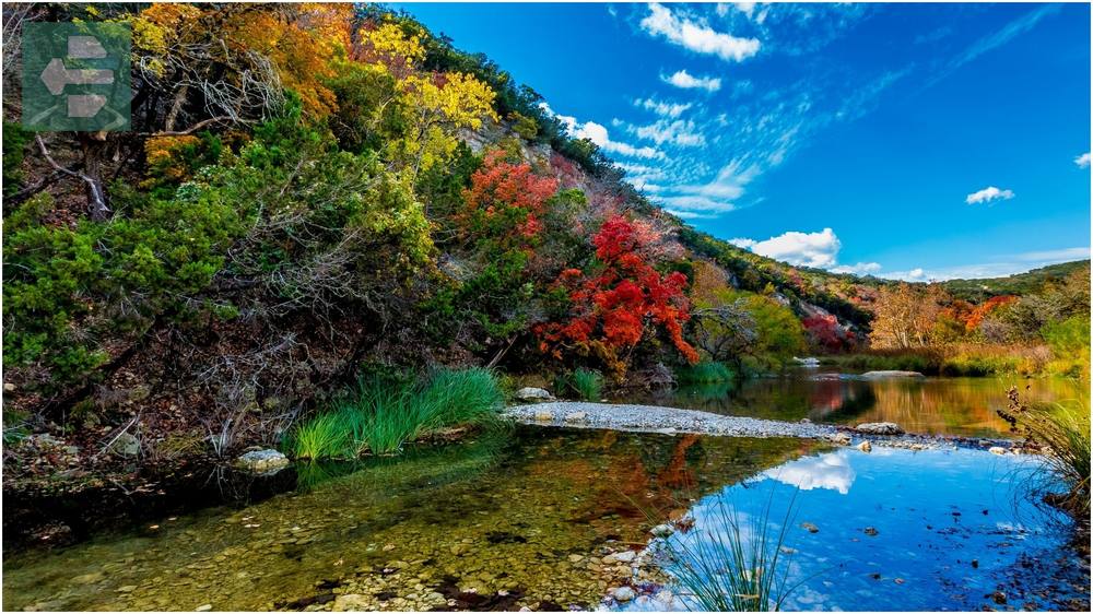
East Trail follows the Sabinal River through maple groves and limestone bluffs. The water runs clear and cold, even in summer heat.
I’ve hiked here in both seasons—November for color, April for wildflowers. Both offer their own magic.
Quick Facts
- Peak Season: November (fall colors), April (wildflowers)
- How to Get There: Highway 187, 5 miles north of Vanderpool
- Entrance Fee: From $7 per person
- Suggested Duration: Full day
- Key Trails: East Trail, West Trail, Limestone Ledge Trail
6. Franklin Mountains State Park: Desert Solitude
Franklin Mountains State Park protects 26,627 acres of Chihuahuan Desert just outside El Paso. The mountains rise abruptly from the desert floor, creating dramatic elevation changes and stunning city views.

North Franklin Mountain Trail climbs to the highest peak, revealing views of three states and two countries. The desert here feels ancient and untouched.
Carry a headlamp even for day hikes. Desert weather changes quickly, and afternoon storms can leave you hiking in darkness.
Quick Facts
- Peak Season: October-April
- How to Get There: Trans Mountain Road, northeast El Paso
- Entrance Fee: From $5 per person
- Suggested Duration: Full day
- Key Trails: North Franklin Mountain Trail, Aztec Cave Trail
7. Colorado Bend State Park: Hidden Springs
Colorado Bend sits where the Colorado River cuts through limestone hills, creating gorges, caves, and hidden springs. Gorman Creek Trail leads to a series of waterfalls that flow even during drought years.

The park feels remote despite being only two hours from Austin. Spicewood Springs Cave requires crawling through tight passages, but rewards explorers with underground pools.
Bring a wetsuit if you plan to swim. Texas springs stay cold year-round.
Quick Facts
- Peak Season: March-May, September-November
- How to Get There: Highway 580, 6 miles southwest of Bend
- Entrance Fee: From $7 per person
- Suggested Duration: Overnight camping recommended
- Key Trails: Gorman Creek Trail, River Trail, Spicewood Springs Cave
8. Barton Creek Greenbelt: Austin’s Backyard
Barton Creek Greenbelt winds 7.9 miles through Austin’s heart, following limestone cliffs and swimming holes that locals have cherished for generations. The trail connects multiple access points, making it perfect for short walks or long adventures.
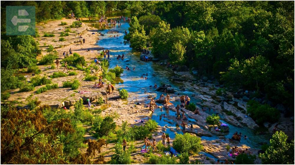
Twin Falls requires a steep scramble down limestone ledges, but the reward is a double waterfall feeding crystal-clear pools. I’ve spent countless summer afternoons here, watching cliff jumpers and listening to live music echo off canyon walls.
Park early on weekends. Austin takes its outdoor spaces seriously.
Quick Facts
- Peak Season: Year-round (avoid summer weekends)
- How to Get There: Multiple access points throughout Austin
- Entrance Fee: Free
- Suggested Duration: 2-4 hours
- Key Spots: Twin Falls, Sculpture Falls, Gus Fruh Pool
9. Ann and Roy Butler Hike and Bike Trail: Urban Oasis
The Butler Trail loops 10.1 miles around Austin’s Town Lake, connecting parks, bridges, and downtown skylines. This isn’t wilderness hiking, but it offers something equally valuable—accessible nature in an urban setting.

The trail passes under Congress Avenue Bridge, home to North America’s largest urban bat colony. Watching 1.5 million bats emerge at sunset never gets old, no matter how many times you’ve seen it.
Rent a bike for the full loop, or walk sections that interest you most.
Quick Facts
- Peak Season: Year-round
- How to Get There: Multiple access points in Austin
- Entrance Fee: Free
- Suggested Duration: 2-6 hours depending on mode
- Key Spots: Congress Bridge, Zilker Park, Long Center
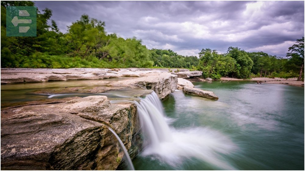
10. McKinney Falls State Park: Limestone Ledges
McKinney Falls combines limestone ledges, cypress trees, and year-round swimming holes just 13 miles from downtown Austin. Onion Creek carved the falls over thousands of years, creating natural slides and deep pools.
The Rock Shelter Trail leads to prehistoric cave paintings, evidence that humans have found peace in this spot for centuries.
Visit after spring rains when the falls run strongest, but be prepared for crowds on hot summer weekends.
Quick Facts
- Peak Season: March-May for wildflowers, summer for swimming
- How to Get There: Highway 183 south, Scenic Loop Road
- Entrance Fee: From $7 per person
- Suggested Duration: Half to full day
- Key Trails: Onion Creek Trail, Rock Shelter Trail, Homestead Trail
11. Pedernales Falls State Park: Hill Country Classic
Pedernales Falls State Park showcases the Hill Country at its finest—limestone slabs, cypress-lined rivers, and spring wildflowers that stretch to the horizon. The falls themselves are more like rapids, where the Pedernales River flows over natural limestone steps.

Wolf Mountain Trail climbs to the park’s highest point, offering panoramic views of the Texas Hill Country that stretch for miles in every direction.
The river pools are perfect for cooling off after hiking, but respect the current during spring floods.
Quick Facts
- Peak Season: April-May (wildflowers), September-November
- How to Get There: Highway 2766, 6 miles east of Johnson City
- Entrance Fee: From $7 per person
- Suggested Duration: Full day
- Key Trails: Wolf Mountain Trail, Twin Falls Trail, Hill Country Nature Trail
12. Inks Lake State Park: Clear Blue Waters
Inks Lake State Park surrounds a constant-level lake created by a dam on the Colorado River. The pink granite hills and clear blue water create scenery that feels more like Minnesota than Texas.

Devil’s Waterhole Trail leads to natural granite slides where generations of Texans have learned to swim. The water stays deep and clear year-round.
Bring a kayak or rent one at the park store. Paddling among pink granite islands offers a different perspective on Hill Country beauty.
Quick Facts
- Peak Season: Year-round (busiest in summer)
- How to Get There: Highway 29 west from Burnet
- Entrance Fee: From $7 per person
- Suggested Duration: Full day or weekend camping
- Key Trails: Devil’s Waterhole Trail, Lake Trail, Valley Spring Trail
Texas hiking offers something no guidebook can capture—the feeling of standing alone in landscapes that dwarf human concerns. These best hiking places in Texas will challenge your legs, clear your mind, and remind you why getting lost sometimes means finding exactly what you need.
Pack your boots. Fill your water bottles.
The trail is waiting.