California’s best places to hike offer incredible diversity from Yosemite’s iconic granite cliffs to Death Valley’s surreal landscapes. The top destinations include Half Dome, Mist Trail, Mount Whitney Trail, and Upper Yosemite Falls Trail. Other exceptional spots are Point Lobos Loop, Torrey Pines Beach Trail, and Big Pine Lakes in the Sierra Nevada Mountains.
Keep reading as we reveal the best places to hike in California that will elevate your outdoor adventures to unforgettable heights.
1. Mist Trail (Yosemite National Park): Nature’s Power Shower
The Mist Trail lives up to its name. Vernal Fall’s spray soaks hikers long before they reach the 317-foot cascade, creating natural air conditioning on hot summer days.
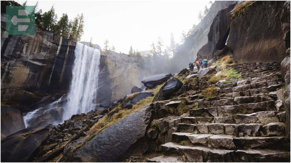
The granite steps carved into the mountainside demand respect. Each step brings you closer to the thundering water that has carved this canyon for millennia.
Start early—by 10 AM, the trail becomes a parade of wet, happy hikers descending while you climb.
Quick Facts:
- Peak Season: May-September
- How to Get There: Happy Isles trailhead via Yosemite Valley shuttle
- Entry Fee: From $35 per vehicle
- Suggested Stay: 2-3 days in Yosemite Valley
- Sub-locations: Vernal Fall, Nevada Fall, Happy Isles
2. Upper Yosemite Falls Trail (Yosemite National Park): Earning the View
This trail punishes your legs for 7.2 miles round-trip, gaining 2,700 feet through switchbacks carved into cliff faces. The reward waits at the top of North America’s tallest waterfall.
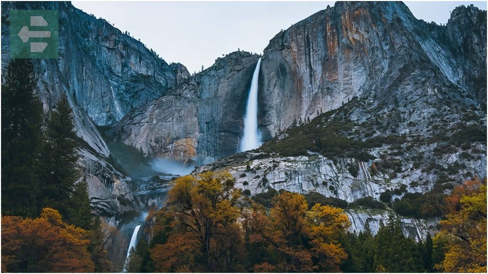
At sunrise, I watched the valley floor emerge from shadow while standing where Yosemite Creek plunges 2,425 feet. That moment made every burning step worthwhile.
Bring more water than you think you need. The exposed granite reflects heat like an oven in summer.
Quick Facts:
- Peak Season: May-October
- How to Get There: Yosemite Falls trailhead near Yosemite Lodge
- Entry Fee: From $35 per vehicle
- Suggested Stay: 3-4 days in Yosemite Valley
- Sub-locations: Columbia Rock, Upper Yosemite Fall, Yosemite Point
3. Half Dome (Yosemite National Park): The Ultimate Test
Half Dome’s cables section separates dreamers from achievers. The final 400 feet require gloves, courage, and absolute focus as you pull yourself up steel cables anchored to bare granite.
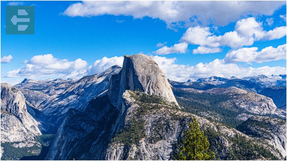
The 17-mile round-trip demands permits, preparation, and respect for the mountain. Weather changes fast at 8,842 feet.
Local rangers recommend starting before dawn. By afternoon, thunderstorms can turn those cables into lightning rods.
Quick Facts:
- Peak Season: May-October (cables up)
- How to Get There: Happy Isles or Mist Trail/John Muir Trail combination
- Entry Fee: From $35 per vehicle plus permit required
- Suggested Stay: 4-5 days minimum
- Sub-locations: Little Yosemite Valley, Sub Dome, Half Dome summit
4. Mount Whitney Trail: California’s Rooftop
Mount Whitney stands at 14,505 feet—the highest point in the contiguous United States. The 22-mile round-trip trail gains 6,100 feet through four distinct ecosystems.
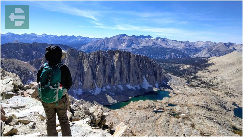
Above 12,000 feet, every breath becomes deliberate. Your body works harder while your mind grows clearer with each step toward the summit.
The permit lottery opens in February. Backup plans include climbing from the west side via Lone Pine Lake trail for acclimatization.
Quick Facts:
- Peak Season: July-September
- How to Get There: Whitney Portal Road from Lone Pine
- Entry Fee: From $6 per person plus permits required
- Suggested Stay: 3-4 days for acclimatization
- Sub-locations: Lone Pine Lake, Mirror Lake, Trail Crest, Summit
5. Lassen Peak Trail (Lassen Volcanic National Park): Active Volcano Views
Lassen Peak last erupted in 1915, and evidence of its volcanic power surrounds you on this 5-mile round-trip climb. Fumaroles still release steam from the mountain’s flanks.
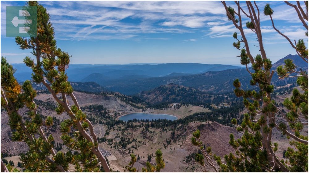
The trail zigzags through pumice and volcanic rock to 10,457 feet. On clear days, Mount Shasta dominates the northern horizon like a white pyramid.
Snow lingers until July most years. Check trail conditions before driving the winding park road.
Quick Facts:
- Peak Season: July-October
- How to Get There: Lassen Peak parking area via Highway 89
- Entry Fee: From $30 per vehicle
- Suggested Stay: 2-3 days
- Sub-locations: Lassen Peak summit, Cinder Cone, Bumpass Hell
6. Torrey Pines Beach Trail Loop: Rare Trees, Endless Ocean
Torrey Pines State Natural Reserve protects the world’s rarest pine tree species. Only 3,000 Torrey pines exist in the wild, and half grow on these coastal bluffs.

The easy 1.5-mile loop combines botanical wonder with Pacific Ocean views. Waves crash 300 feet below while ancient trees twist in shapes sculpted by salt wind.
Visit during weekdays to avoid crowds. The trees look most dramatic in late afternoon light.
Quick Facts:
- Peak Season: October-April
- How to Get There: Torrey Pines State Natural Reserve entrance
- Entry Fee: From $15 per vehicle
- Suggested Stay: Half day
- Sub-locations: Razor Point, Beach Trail, Guy Fleming Trail
7. Point Lobos Loop (Point Lobos State Natural Reserve): Monterey’s Crown Jewel
Point Lobos earns its nickname as the “crown jewel” of California’s state park system. Sea otters float in kelp forests while Monterey cypress trees frame every coastal vista.

The 6-mile loop trail system connects hidden coves where harbor seals rest on rocks between waves. Each turn reveals another postcard scene.
Early morning visits offer the best wildlife viewing. Sea otters are most active before tourist crowds arrive.
Quick Facts:
- Peak Season: April-October
- How to Get There: Highway 1 south of Carmel-by-the-Sea
- Entry Fee: From $10 per vehicle
- Suggested Stay: Full day
- Sub-locations: China Rock, Bird Rock, Cypress Point Lookout
8. Hollywood Sign Hike (via Brush Canyon Trail): Icons and Exercise
The Hollywood Sign hike via Brush Canyon Trail offers the closest legal approach to those famous white letters. The 6.2-mile round-trip climbs through chaparral-covered hills above Los Angeles.

From Mount Lee’s summit, the entire LA basin spreads below while the 45-foot-tall letters loom overhead. Smog permitting, you can see to Catalina Island.
Start early to beat heat and crowds. Parking fills quickly on weekends as Instagram seekers hunt the perfect shot.
Quick Facts:
- Peak Season: October-April
- How to Get There: Canyon Drive entrance in Griffith Park
- Entry Fee: Free
- Suggested Stay: Half day
- Sub-locations: Mount Lee summit, Hollywood Sign viewpoint, Griffith Observatory
9. Potato Harbor (Channel Islands National Park): California’s Galapagos
Santa Cruz Island’s Potato Harbor Trail leads to a crescent-shaped cove that resembles a giant potato when viewed from above. The 5-mile round-trip crosses grasslands where island foxes—found nowhere else—dart between native plants.

The channel crossing by boat takes 90 minutes, but arriving feels like stepping into prehistoric California. No cars, no roads, just wind and waves.
Pack everything you need. Island weather changes fast, and return boats don’t wait for unprepared hikers.
Quick Facts:
- Peak Season: April-October
- How to Get There: Ferry from Ventura or Santa Barbara harbors
- Entry Fee: Ferry costs vary, park entry free
- Suggested Stay: Full day or camping overnight
- Sub-locations: Potato Harbor overlook, Cavern Point, Scorpion Canyon
10. 49 Palms Oasis Trail (Joshua Tree National Park): Desert’s Secret Garden
The 49 Palms Oasis Trail reveals Joshua Tree’s hidden side. Fan palms cluster around a natural spring, creating an unlikely oasis in the Mojave Desert.

The 3-mile round-trip crosses boulder fields and desert washes before reaching palms that have grown here for centuries. Water seeps from granite cracks year-round.
Bring plenty of water despite the destination. Desert sun dehydrates faster than mountain altitude.
Quick Facts:
- Peak Season: October-April
- How to Get There: 49 Palms Oasis trailhead off Canyon Road
- Entry Fee: From $30 per vehicle
- Suggested Stay: 2-3 days
- Sub-locations: 49 Palms Oasis, Indian Canyons, Lost Palms Oasis
11. Death Valley National Park Trails: Beauty in Extremes
Death Valley’s trails lead through landscapes that seem designed by aliens. Badwater Basin sits 282 feet below sea level while telescope Peak rises to 11,043 feet—both in the same park.
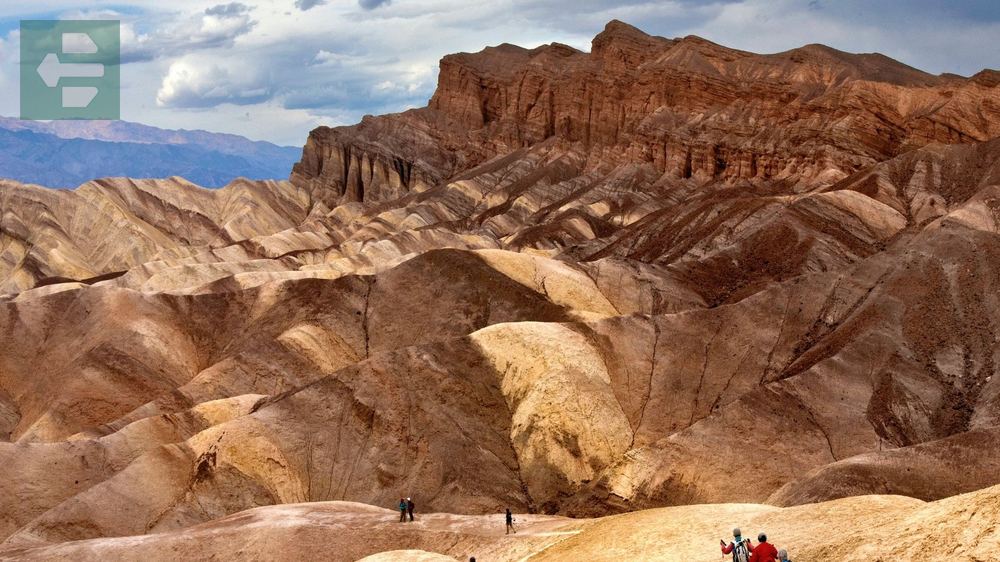
The Mesquite Flat Sand Dunes shift constantly, erasing yesterday’s footprints while creating new ridges for tomorrow’s sunrise. Star Wars filmed here for good reason.
Summer temperatures exceed 120°F. Visit between October and April when desert blooms transform the valley floor.
Quick Facts:
- Peak Season: November-March
- How to Get There: Multiple entrances via Highway 190 or 178
- Entry Fee: From $30 per vehicle
- Suggested Stay: 3-4 days minimum
- Sub-locations: Badwater Basin, Artists Palette, Zabriskie Point, Mesquite Flat Dunes
12. Donner Peak Trail (Truckee): Sierra History Lesson
Donner Peak’s 7,057-foot summit overlooks Donner Lake and the Sierra Nevada crest. The 4-mile round-trip climbs through granite formations shaped by glaciers and time.

History weighs heavy here. The Donner Party’s struggle happened in the valley below, while railroad workers blasted tunnels through solid rock above.
Wildflowers peak in July, painting meadows purple with lupine and red with Indian paintbrush.
Quick Facts:
- Peak Season: June-October
- How to Get There: Mount Judah Loop trailhead off Old Highway 40
- Entry Fee: Free
- Suggested Stay: 1-2 days
- Sub-locations: Donner Peak summit, Mount Judah Loop, Donner Lake overlook
13. Bluff Top Trail (Gualala): Rugged Coast Simplicity
The Bluff Top Trail follows Gualala’s dramatic coastline where the Pacific Ocean carves sea stacks from ancient marine terraces. The easy 3-mile round-trip stays level while waves crash below.

Wildflowers bloom year-round in the coastal climate. Gray whales pass offshore during migration seasons, December through April.
Fog rolls in most afternoons. Morning hikes offer clearer views and calmer winds.
Quick Facts:
- Peak Season: April-October
- How to Get There: Gualala Point Regional Park entrance
- Entry Fee: From $7 per vehicle
- Suggested Stay: Half day
- Sub-locations: Gualala Point, Sea Ranch trails, Bluff Top Trail overlooks
14. Big Pine Lakes (Sierra Nevada Mountains): Alpine Mirror Collection
Big Pine Lakes nestled beneath the Palisades Glacier represent California’s largest glacier system. The 10-mile round-trip climbs through seven alpine lakes, each reflecting granite spires.

Above 10,000 feet, the air thins while scenery intensifies. Temple Crag and Mount Sill tower over emerald lakes fed by snowmelt and glacier runoff.
Afternoon thunderstorms build quickly in summer. Start early and watch the western sky for developing clouds.
Quick Facts:
- Peak Season: July-September
- How to Get There: Big Pine Creek Road from Highway 395
- Entry Fee: Free, wilderness permits required for overnight
- Suggested Stay: 2-3 days
- Sub-locations: First Lake, Second Lake, Black Lake, Summit Lake
15. Mount Tallac Trail (Lake Tahoe): Crown Jewel Views
Mount Tallac’s 9,735-foot summit offers Lake Tahoe’s most spectacular panoramic view. The 10-mile round-trip climbs 3,300 feet through forest, meadows, and granite slabs.

From the summit, Lake Tahoe spreads 22 miles long and 12 miles wide, so clear you can see the bottom 1,600 feet down in some places.
The final push crosses loose rock. Trekking poles help with balance and reduce knee stress on the descent.
Quick Facts:
- Peak Season: June-October
- How to Get There: Mount Tallac trailhead off Highway 89
- Entry Fee: Free
- Suggested Stay: 2-3 days around Lake Tahoe
- Sub-locations: Floating Island Lake, Cathedral Lake, Mount Tallac summit
California’s best places to hike wait for you across 15 diverse landscapes. Each trail tells a different story through granite and sand, forest and desert, ocean and mountain peak.
Your boots will carry you from Yosemite’s waterfalls to Death Valley’s dunes. Your lungs will work harder at Whitney’s summit and breathe easier on Torrey Pines’ coastal paths.
Pack light but dream big. California’s trails reward those who show up prepared and leave inspired.
The mountains are calling. Answer them.