Oregon delivers some of America’s most diverse hiking experiences, from thundering waterfalls to alpine lakes and rugged coastlines. The best places to hike in Oregon include Trail of Ten Falls, Mirror Lake Loop, Angel’s Rest, and the dramatic Oregon Coast Trail.
Keep reading as we uncover Oregon’s most spectacular trails that will transform your next adventure into an unforgettable journey through the Pacific Northwest’s finest landscapes.
1. Trail of Ten Falls (Silver Falls State Park): Oregon’s Crown Jewel
This 7.2-mile loop takes you behind ten waterfalls, including the 177-foot South Falls where you walk directly behind the cascade. The trail feels like stepping into a living cathedral of moss and mist.
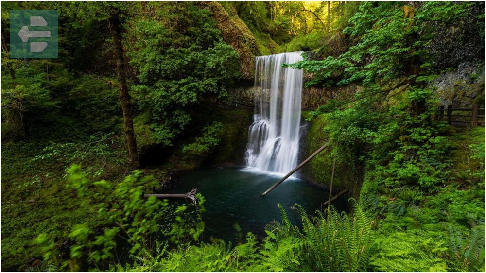
I’ll never forget standing behind North Falls on a foggy October morning, watching the world disappear into silver curtains while water thundered inches from my face. That moment taught me why locals call this the “crown jewel of Oregon hiking.”
The trail connects all ten falls through old-growth forest, with boardwalks and stone steps carved into cliffsides. Start early to have the falls mostly to yourself.
Quick Facts:
- Peak Season: April-October
- Access: Highway 214 to Silver Falls State Park
- Fees: From day-use parking fee
- Suggested Stay: 1-2 days
- Notable Falls: South Falls, North Falls, Winter Falls, Drake Falls
2. Latourell Falls Loop: Columbia River Gorge Classic
This 2.3-mile loop showcases the Columbia River Gorge’s raw power through two distinct waterfall experiences. Latourell Falls plunges 249 feet over ancient basalt columns, while Upper Latourell offers intimate creek views.
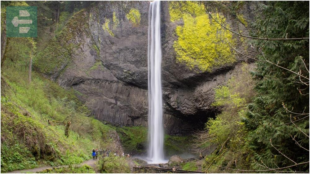
The trail climbs steeply through Douglas fir forest to viewpoints that frame the Columbia River below. Spring brings wildflowers that carpet the canyon walls.
Pack layers—the gorge creates its own weather patterns, and conditions change quickly between exposed viewpoints and shaded creek beds.
Quick Facts:
- Peak Season: March-November
- Access: Historic Columbia River Highway
- Fees: From parking pass required
- Suggested Stay: Half day
- Features: Basalt columns, gorge views, spring wildflowers
3. Ramona Falls Trail: Mount Hood’s Hidden Cascade
This 7-mile round trip leads to one of Mount Hood’s most photogenic waterfalls, where Ramona Creek fans out over a 120-foot basalt wall like nature’s own wedding veil. The approach winds through old-growth forest and across the Sandy River on a suspension bridge.
You’ll cross multiple creek beds on log bridges—each one offering glimpses of Mount Hood through the canopy. The final approach opens into a natural amphitheater where Ramona Falls creates its own microclimate.
Visit on weekdays if possible. This trail has gained popularity, but solitude still exists for those willing to start before sunrise.
Quick Facts:
- Peak Season: June-October
- Access: Lolo Pass Road (Forest Road 18)
- Fees: From forest pass required
- Suggested Stay: Full day
- Highlights: Sandy River bridge, Mount Hood views, fan-shaped falls
4. Wahclella Falls Trail: Gorge Intimacy
This easy 2-mile round trip proves that Oregon’s best hikes don’t always require epic distances. Wahclella Falls drops 350 feet in multiple tiers, ending in a perfect swimming hole surrounded by towering canyon walls.
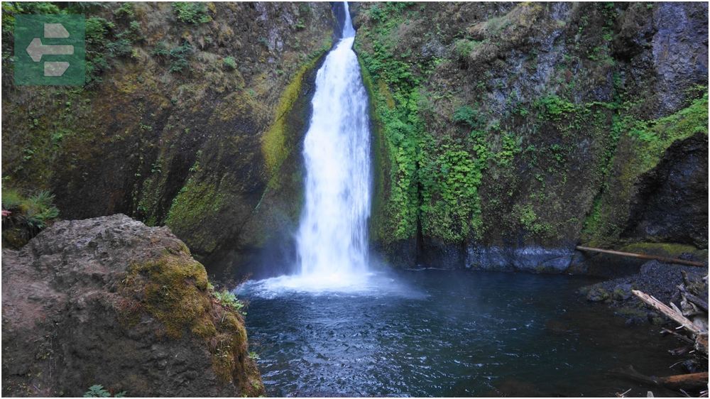
The trail follows Tanner Creek through a narrow gorge where walls close in and create cathedral-like acoustics. Every footstep echoes, and the sound of falling water grows louder with each turn.
Local photographers know the best light hits the falls between 10 AM and noon when sun penetrates the narrow canyon. Bring a wide-angle lens to capture the full scene.
Quick Facts:
- Peak Season: Year-round
- Access: Historic Columbia River Highway
- Fees: From day-use parking
- Suggested Stay: 2-3 hours
- Features: Swimming hole, narrow gorge, multi-tier falls
5. Drift Creek Falls: Coastal Range Surprise
This 3-mile round trip leads to a 75-foot waterfall viewed from a spectacular suspension bridge that spans the creek canyon 100 feet above the forest floor. The bridge sways gently, adding adventure to the viewing experience.
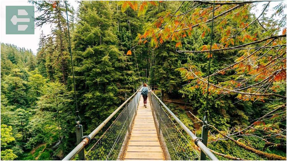
The trail descends through second-growth forest where massive stumps hint at the old-growth giants that once dominated this landscape. Ferns carpet the forest floor in shades of green that seem impossible.
During winter storms, the bridge becomes a front-row seat to nature’s power as Drift Creek swells and roars through the canyon below.
Quick Facts:
- Peak Season: Year-round (best in winter/spring)
- Access: Drift Creek Falls Trail Road
- Fees: From parking fee
- Suggested Stay: Half day
- Features: Suspension bridge, old-growth stumps, winter accessibility
6. Angel’s Rest Trail: Columbia Gorge Vista
This 4.6-mile round trip climbs 1,500 feet to one of the Columbia River Gorge’s most accessible viewpoints. The trail switchbacks through oak and Douglas fir before opening onto basalt cliffs with panoramic river views.

Standing on Angel’s Rest at sunset, watching cargo ships navigate the Columbia while Crown Point glows in golden light, reminds you why this gorge carved itself into the collective imagination of the Pacific Northwest.
The final approach crosses exposed rock faces where painted trail markers guide you to the summit. Wind can be fierce—bring layers and secure loose items.
Quick Facts:
- Peak Season: March-November
- Access: Bridal Veil Falls exit off I-84
- Fees: From parking pass
- Suggested Stay: Half day
- Views: Columbia River, Crown Point, Beacon Rock, Mount Hood
7. Misery Ridge Trail (Smith Rock State Park): Desert Drama
This 3.7-mile loop climbs Smith Rock’s iconic formations through high desert terrain that feels more like Utah than Oregon. The trail gains 1,000 feet of elevation over exposed rock faces and juniper-dotted ridges.

From Misery Ridge’s summit, the Cascade Mountains stretch across the horizon while climbers scale the park’s famous spires below. The contrast between red rock and snow-capped peaks creates one of Oregon’s most dramatic landscapes.
Carry extra water—this desert environment shows no mercy to unprepared hikers. Start early during summer months when temperatures can exceed 100 degrees.
Quick Facts:
- Peak Season: April-June, September-November
- Access: Smith Rock State Park entrance
- Fees: From day-use parking
- Suggested Stay: Full day
- Features: Rock climbing views, high desert, Cascade panoramas
8. Mirror Lake Loop Trail (Mount Hood National Forest): Alpine Perfection
This 3.2-mile round trip leads to a pristine alpine lake that perfectly reflects Mount Hood’s peak when conditions align. The trail gains 700 feet through mountain hemlock and noble fir forest.

I’ve visited Mirror Lake dozens of times, but nothing compares to arriving at dawn when the lake becomes glass and Mount Hood’s reflection doubles the mountain’s presence. Those moments of perfect stillness feel like nature’s reset button.
The loop continues beyond the lake through meadows that explode with wildflowers in late July. Snow lingers here well into summer, so check conditions before visiting.
Quick Facts:
- Peak Season: July-October
- Access: Government Camp via Highway 26
- Fees: From forest pass
- Suggested Stay: Half day
- Features: Mount Hood reflection, alpine meadows, old-growth forest
9. Proxy Falls: McKenzie Pass Marvel
This easy 1.6-mile loop showcases two distinct waterfalls in the volcanic landscape of McKenzie Pass. Upper Proxy Falls plunges 226 feet over a lava cliff, while Lower Proxy Falls creates multiple cascades through ancient lava flows.

The trail crosses rough lava rock where water disappears underground, creating an otherworldly landscape of moss-covered boulders and hidden streams that emerge from nowhere.
Visit during snowmelt season when the falls reach maximum volume. The volcanic terrain here tells the story of Oregon’s fiery past in every twisted rock formation.
Quick Facts:
- Peak Season: June-October
- Access: McKenzie Pass Highway (Hwy 242)
- Fees: From forest pass required
- Suggested Stay: 2-3 hours
- Features: Lava flows, dual waterfalls, volcanic landscape
10. Oregon Coast Trail: Pacific Edge Adventure
This 382-mile trail follows Oregon’s entire coastline, but shorter sections offer perfect day hikes along dramatic headlands and pristine beaches. Each segment reveals different coastal personalities from rocky tidepools to massive sand dunes.

Walking the trail near Cannon Beach at low tide, with Haystack Rock emerging from morning fog while waves crash against sea stacks, captures the raw beauty that defines Oregon’s coast.
Tide charts become your best friend here. Plan your hike around low tide to access the best tidepool areas and avoid getting trapped by rising water.
Quick Facts:
- Peak Season: Year-round (check weather)
- Access: Multiple trailheads along Highway 101
- Fees: From parking varies by location
- Suggested Stay: Multiple days for full experience
- Highlights: Haystack Rock, tidepools, sea stacks, beaches
11. Green Lakes Trail (Three Sisters Wilderness): Volcanic Wonderland
This 8.4-mile round trip climbs to three pristine alpine lakes nestled beneath South Sister’s volcanic slopes. The trail gains 1,100 feet through diverse ecosystems from dense forest to exposed pumice fields.

The Green Lakes live up to their name—glacial flour suspended in the water creates an emerald color that seems artificial until you see it reflecting the surrounding peaks.
Mosquitoes can be brutal during peak snowmelt season. Bring protection and consider visiting in early fall when bugs diminish but lakes remain accessible.
Quick Facts:
- Peak Season: July-October
- Access: Green Lakes Trailhead via Cascade Lakes Highway
- Fees: From wilderness permit required
- Suggested Stay: Full day or overnight
- Features: Alpine lakes, South Sister views, volcanic landscape
12. Saddle Mountain Trail: Coastal Range Summit
This 5.2-mile round trip climbs to the highest peak in Oregon’s Coast Range, offering views from the Pacific Ocean to the Cascade Mountains. The trail gains 1,600 feet through rare wildflower meadows and old-growth forest.

From Saddle Mountain’s 3,283-foot summit on a clear day, you can see five Cascade volcanoes while ocean fog rolls through coastal valleys below. It’s one of the few places where Oregon’s geographic diversity unfolds in a single panorama.
The final approach crosses narrow ridges with steep drop-offs. Use caution in wet conditions when basalt rock becomes extremely slippery.
Quick Facts:
- Peak Season: April-October
- Access: Saddle Mountain Road off Highway 26
- Fees: From day-use parking
- Suggested Stay: Half day
- Views: Pacific Ocean, Cascade Mountains, coastal valleys
13. Tamolitch Blue Pool (Willamette National Forest): Desert Oasis
This 4.4-mile round trip follows the McKenzie River Trail to an otherworldly blue pool where the river emerges from underground lava tubes. The water maintains a constant 37-degree temperature year-round.

Standing beside Tamolitch Pool feels like discovering a hidden gem that shouldn’t exist. The water glows electric blue against black lava rock, creating a color combination that challenges photography.
The pool sits in a wide basin surrounded by lava flows and old-growth forest. Swimming is possible but brief—the water temperature quickly reminds you of its glacial origins.
Quick Facts:
- Peak Season: Year-round
- Access: Trail Bridge Reservoir off McKenzie Highway
- Fees: From forest pass required
- Suggested Stay: Half day
- Features: Blue pool, lava tubes, McKenzie River, swimming
14. Mount Howard Trail (Wallowa Mountains): Alpine Grandeur
This network of trails accessible via the Wallowa Lake Tramway offers high-alpine hiking without the grueling ascent. Multiple loops explore ridges and meadows at 8,000 feet elevation.

The tramway ride itself becomes part of the adventure, climbing 3,700 vertical feet in 15 minutes while the Wallowa Valley shrinks below. At the summit, trails wind through terrain that rivals the European Alps.
Afternoon thunderstorms develop quickly in the Wallowas. Start early and be prepared to descend if weather deteriorates. The tramway provides easy escape when needed.
Quick Facts:
- Peak Season: June-September
- Access: Wallowa Lake Tramway
- Fees: From tramway ticket required
- Suggested Stay: Half day
- Features: Alpine meadows, tramway access, Wallowa Valley views
Oregon’s hiking trails offer endless adventures across landscapes that shift from desert to alpine to coastal within hours of driving. Each trail reveals different facets of the state’s natural character.
Whether you’re chasing waterfalls in the Columbia River Gorge or seeking solitude in the Wallowa Mountains, Oregon’s best places to hike deliver experiences that linger long after your boots dry.
Pack your daypack. Check the weather. Choose your trail.
The mountains are calling, and Oregon has fourteen perfect answers waiting for your next adventure.